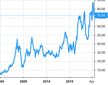
 Stock Value
About Southern Copper Corp
Southern Copper Corporation (SCC) operates as an integrated copper producer worldwide.
The company’s major production includes copper, molybdenum, zinc and silver. All of the company’s mining, smelting and refining facilities are located in Peru and Mexico and the company conduct exploration activities in those countries and in Argentina, Chile and Ecuador.
The company’s Peruvian copper operations involve mining, milling and flotation of copper ore to produce copper concentrates and molybdenum concentrates; the smelting of copper concentrates to produce blister and anode copper; and the refining of anode copper to produce copper cathodes. As part of this production process, the company also produces significant amounts of molybdenum concentrate and sulfuric acid. The company’s precious metals plant at the Ilo refinery produces refined silver, gold, and other materials. Additionally, the company produces refined copper using solvent extraction/electrowinning technology (‘SX-EW’). The company operates the Toquepala and Cuajone open-pit mines high in the Andes Mountains, approximately 860 kilometers southeast of the city of Lima, Peru. The company also operates a smelter and refinery west of the Toquepala and Cuajone mines in the coastal city of Ilo, Peru.
The company’s Mexican operations are conducted through its subsidiary, Minera Mexico, S.A. de C.V. (‘Minera Mexico’). Minera Mexico engages primarily in the mining and processing of copper, molybdenum, zinc, silver, gold and lead. Minera Mexico operates through subsidiaries that are grouped into three separate units. Mexicana de Cobre, S.A. de C.V. (together with its subsidiaries, the ‘La Caridad’ unit) operates La Caridad, an open-pit copper mine, a copper ore concentrator, a SX-EW plant, a smelter, refinery and a rod plant. The La Caridad refinery has a precious metals plant that produces refined silver, gold and other materials. Operadora de Minas e Instalaciones Mineras, S.A de C.V. (the ‘Buenavista unit’) operates Buenavista, an open-pit copper mine, which is located on the site of one of the world’s largest copper ore deposits, two copper concentrators and two operating SX-EW plants. Industrial Minera Mexico, S.A. de C.V. (together with its subsidiaries, the ‘IMMSA unit’) operates five underground mines that produce zinc, lead, copper, silver and gold, and a zinc refinery.
The company utilizes modern, state of the art mining and processing methods, including global positioning systems and computerized mining processes. The company’s operations have a high level of vertical integration, which allows the company to use its facilities, employees and equipment to manage the entire production process, including ore mining and production of refined copper rod and other products, and to execute most associated transport and logistics functions.
The company is a majority-owned, indirect subsidiary of Grupo Mexico S.A.B. de C.V. (‘Grupo Mexico’). As of December 31, 2022, Grupo Mexico, through its wholly-owned subsidiary, Americas Mining Corporation (‘AMC’), owned 88.9% of the company’s capital stock. Grupo Mexico’s principal business is to act as a holding company for the shares of other corporations engaged in the mining, processing, purchase and sale of minerals and other products and in the provision of railway and other related services.
The company conducts its operations in Peru through a registered branch (the ‘SPCC Peru Branch,’ ‘Branch’ or ‘Peruvian Branch’). The SPCC Peru Branch comprises virtually all of the company’s assets and liabilities associated with its copper operations in Peru.
In April 2005, the company acquired Minera Mexico, from Americas Mining Corporation (‘AMC’), a subsidiary of Grupo Mexico, the company’s controlling stockholder. Minera Mexico is a holding company and all of its operations are conducted through subsidiaries that are grouped into three units: the La Caridad unit, the Buenavista unit, and the IMMSA unit. The company owns 99.96% of Minera Mexico.
The company’s revenues are derived primarily from the company’s operations in Peru and Mexico.
Segments
Peruvian Operations segment
Peruvian operations, which include the Toquepala and Cuajone mine complexes and the smelting and refining plants, including a precious metals plant, industrial railroad and port facilities that service both mines. Sales of its products are recorded as revenue from the company’s Peruvian mines. The Peruvian operations produce copper, by-products of molybdenum, silver and other materials.
Mexican Open-Pit Operations segment
Mexican open-pit operations, which include the La Caridad and Buenavista mine complexes and the smelting and refining plants, including a precious metals plant and a copper rod plant and support facilities that service both mines. Sales of its products are recorded as revenue of the company’s Mexican mines. The Mexican open-pit operations produce copper, with production of by-products of molybdenum, silver and other materials.
Mexican Underground Mining Operations segment
Mexican underground mining operations, which include five underground mines that produce zinc, copper, lead, silver and gold; and a zinc refinery. This group is identified as the IMMSA unit and sales of its products are recorded as revenue from the IMMSA unit.
Principal Products and Markets
The company focuses on end-user customers as opposed to selling on the spot market or to trading companies. In addition, the company devotes significant marketing efforts to diversifying the company’s sales both by region and customer base. The company also strives to provide superior customer service, including timely deliveries of the company’s products. The company’s ability to consistently fulfill customer demand is underpinned by the company’s substantial production capacity.
Mining Rights and Concessions
Peru
The company has 237,102 hectares in concessions from the Peruvian government for the company’s exploration, exploitation, extraction and production operations.
The company has two types of mining concessions in Peru: metallic and non-metallic concessions.
Mexico
In Mexico, the company has 493,117 hectares in concessions from the Mexican government for the company’s exploration and exploitation activities.
Properties
The company operates open-pit copper mines in the southern part of Peru—at Toquepala and Cuajone—and in Mexico, at La Caridad and Buenavista. The company also owns five underground mines, three out of which produce zinc, copper, silver and gold.
Extraction, Smelting and Refining Processes
The company’s operations include open-pit and underground mining, concentrating, copper smelting, copper refining, copper rod production, solvent extraction/electrowinning (‘SX-EW’), zinc refining, sulfuric acid production, molybdenum concentrate production and silver and gold refining.
Tailings Dams
The company has six tailings dams in operation in Mexico and one in Peru.
Peruvian Operations
Operations in the company’s Peruvian segment include the Cuajone and Toquepala mine complexes and the smelting and refining plants, the industrial railroad that links Ilo, Toquepala and Cuajone and the port facilities. Other properties include the company’s Tia Maria, Los Chancas and Michiquillay projects. The company conducts ongoing maintenance and improvement programs to ensure the satisfactory performance of the company’s equipment.
Cuajone
The Cuajone operations consist of an open-pit copper mine and a concentrator and are located in the Torata District, Mariscal Nieto Region, of Moquegua, approximately 878 km from the city of Lima and 27 km from the city of Moquegua. The Cuajone mine is accessible by paved road from Lima or Tacna by the Pan-American Highway. The Quebrada Honda tailings storage facility (‘TSF’) is about 120 km via local roads, south of the Cuajone operations. Access within the project area is via developed roads that are routinely maintained. Tacna, Moquegua, and Ilo have regularly scheduled air services from Lima. Additionally, a spur railway runs from the Toquepala operations to the Cuajone operations.
The Cuajone operations are owned and operated by SPCC Peru Branch and contain a single mining concession, ‘Acumulación Cuajone’, which covers an area of 15,024.5 hectares. Power is transmitted for process needs from the Peruvian grid using two Southern Copper-owned transmission lines of 138 kV and 220 kV. Additionally, the Cuajone operations use surface and underground water from a variety of sources as a fresh make up water.
The property is in the production stage. Southern Copper has had an interest in the Cuajone area since 1954. Predecessor companies included Cerro de Pasco Corporation, Newmont and Asarco. The company’s Cuajone operations utilize a conventional open-pit mining method to drill/blast/haul copper ore for further processing at the concentrator, which has a milling capacity of 90,000 tonnes per day.
The Cuajone deposit is considered to be an example of a porphyry copper–molybdenum deposit. The basal regional geology consists of Precambrian metamorphic rocks that are cut by Paleozoic granite, unconformably overlain by Upper Triassic to Jurassic marine volcanic and sedimentary lithologies. Overlying these rocks are late Cretaceous to early Tertiary rhyolite, andesite and agglomerate of the Toquepala Group. These lithologies are intruded by the composite, polyphase Cretaceous to Paleogene Coastal (Andean) Batholith.
Mineralization and alteration at the Cuajone deposit is directly related to a multi-stage latite porphyry that intrudes basaltic andesites and the overlying 370 m of rhyolite porphyries of the Toquepala Group. The Cuajone porphyry deposit exhibits a zoned alteration pattern that includes potassic, propylitic, sericitic and intermediate argillic hydrothermal alteration styles. The mineralogy is typically simple and consists of pyrite, chalcopyrite, and bornite, with sparse sphalerite, galena, and enargite.
The company’s Cuajone operations use state-of-the-art computer monitoring systems at the concentrator, the crushing plant and the flotation circuit to coordinate inflows and optimize operations.
Tailings are sent to thickeners to recover water. The remaining tailings are sent to the Quebrada Honda dam, the company’s principal tailings storage facility.
Toquepala
The Toquepala operations are situated in Southern Peru, approximately 150 km by road from the city of Tacna and 30 kilometers from Cuajone. Road access from Tacna is via the Pan-American highway and other local roads. Alternative access is from Lima, using the Pan-American highway to Alto Camiara, and then driving for 70 km on a paved road to the Toquepala camp. The Quebrada Honda tailings storage facility (TSF) is 40 km south of the mine, and is accessed via the MO-107 route that that connects Alto Camiara with Toquepala. Within the operations area, access is by unpaved mine and exploration roads. The city of Tacna has a regional airstrip, with regular service within Peru. Additionally, railways extend from Ilo to Toquepala, and a spur railway runs from the Toquepala operations to the Cuajone operations.
The Toquepala operations are owned and operated by SPCC Peru Branch and contain a single mining concession, ‘Acumulación Toquepala 1’, which covers an area of 17,552.4 hectares. Power is transmitted for process needs from the Peruvian grid using two Southern Copper-owned transmission lines of 138 kV and 220 kV. Additionally, the Toquepala operations use surface and underground water from a variety of sources as a fresh make up water.
The property is under the production stage. The company’s Toquepala operations consist of an open-pit copper mine and two concentrators; each with a milling capacity of 60,000 tonnes per day. The company also refine copper at the SX-EW facility through a leaching process. The SX-EW facility has a production capacity of 56,336 tonnes per year of LME grade A copper cathodes. Southern Copper has had an interest in the Project area since 1945. Prior to Southern Copper’s Project interests, the area had been subject to artisanal mining activities. The company’s Toquepala operations utilize a conventional open-pit mining method to collect copper ore for further processing in the company’s concentrators. The second concentrator began operations in the fourth quarter of 2018.
The Toquepala deposit is an example of a copper–molybdenum porphyry deposit. The basal regional geology consists of Precambrian metamorphic rocks that are cut by Paleozoic granite, unconformably overlain by Upper Triassic to Jurassic marine volcanic and sedimentary lithologies. Overlying these rocks are late Cretaceous to early Tertiary rhyolite, andesite and agglomerate of the Toquepala Group. These lithologies are intruded by the composite, polyphase Cretaceous to Paleogene Coastal (Andean) Batholith.
The company’s Toquepala concentrators use state-of-the-art computer monitoring systems to coordinate inflows and optimize operations.
SX-EW Plant
The SX-EW facility at Toquepala produces grade A LME electrowon copper cathodes of 99.999% purity from solutions obtained by leaching low-grade ore stored at the Toquepala and Cuajone mines. The leach plant commenced operations in 1995 with a design capacity of 35,629 tonnes per year of copper cathodes. In 1999, the capacity was expanded to 56,336 tonnes per year.
This facility processes copper oxides from Cuajone and copper sulfides from Toquepala. Copper oxides from Cuajone with a copper grade higher than 0.289%; acid solubility index higher than 42%; and a cyanide solubility index higher than 21% are leached. At Toquepala, the copper sulfides cutoff grade is 0.079% and therefore, material with a total copper grade between 0.065% and 0.33% is leached. Copper in solution produced at Cuajone is sent to Toquepala through an eight-inch pipe laid alongside the Cuajone-Toquepala railroad track.
Plant and equipment are supported by a maintenance plan and a quality management system to assure good physical condition and high availability. The company is implementing the ISO 45000:2018 standard.
Processing Facilities—Ilo
The company’s Ilo smelter and refinery complex is located in the southern part of Peru, 17 kilometers north of the city of Ilo, 121 kilometers from Toquepala, 147 kilometers from Cuajone and 871 kilometers from the city of Lima. Access is by plane from Lima to Tacna (1:40 hours) and then by highway to the city of Ilo (2:00 hours). Additionally, the company operate a port facility in Ilo, from where the company ship the company’s products and receive supplies. Products shipped and supplies received are moved between Toquepala, Cuajone and Ilo on the company’s industrial railroad.
Smelter
The company’s Ilo smelter produces copper anodes for the refinery the company operate as part of the same facility. When the copper produced by the smelter exceeds the refinery’s capacity, the excess is sold to other refineries around the world. In 2007, the company completed a major modernization of the smelter. The nominal installed capacity of the smelter is 1,200,000 tonnes of copper concentrate per year. Copper concentrates from Toquepala and Cuajone are transported by railroad to the smelter, where they are smelted using an ISASMELT furnace, converters and anode furnaces to produce copper anodes with 99.7% copper.
The smelter also has two oxygen plants. Plant No. 1, which has a production capacity of 272 tonnes per, and Plant No.2, with a capacity of 1,045 tonnes per day. This facility also has auxiliary plants (sea water intake and two desalinization plants).
Refinery
The Ilo refinery consists of an electrolytic plant, a precious metal plant and a number of ancillary facilities. The refinery is producing grade A copper cathode of 99.998% purity. The plant was acquired in 1994 and modernized to produce 246,000 t/a of copper cathodes. It was subsequently expanded to the current nominal capacity of 294,763 tonnes per year. Anodic slimes are recovered from the refining process and then sent to the precious metals facility to produce refined silver, refined gold and commercial grade selenium.
In addition to the processing facilities, the refinery has a production control section, a laboratory that provides sample analysis throughout the company, a maintenance department, a desalinization plant and other support facilities.
Other facilities in Ilo include a coquina plant with a production capacity of 200,000 tonnes of seashells per year; this facility, however, has been declared in progressive closure. In addition, the company had a lime plant with a capacity of 80,000 tonnes per year, which has suspended its operations. The company also operates an industrial railroad to haul production and supplies between Toquepala, Cuajone and Ilo.
Tia Maria Project
The Tia Maria Project is in the District of Cocachacra, Mejia and Deán Valdivia, Province of Islay, and Arequipa Region. The Project is located 118 km from Moquegua, 125 km from Arequipa, 120 km from the District of Ilo, and 980 km from Lima. The mine gate will be situated at Pampa Cachendo.
The Project covers an area of 34.689.6 hectares in 55 concessions. The company has easement agreements in place that cover the proposed powerline route and the planned water pipeline that will run from the envisaged desalination plant to the mine. Additionally, the project holds no water rights and the mine plan assumes that water for process operations will be sourced from a desalination plant. The project envisions a 120,000 ton annual SX-EW plant and the mine plans assume conventional open pit mining methods from the La Tapada and Tia Maria deposits. The property is under the development stage.
The La Tapada and Tía Maria deposits are within the northwest–southeast-trending Tambo–El Toro structural corridor that appears to be a large dextral shear zone.
Los Chancas Project
The Los Chancas project is located in the Andes Range in southern Peru. The project covers 22,700 hectares in 31 concessions. Surface rights are being negotiated. The area where surface rights are required is within the Tiaparo and Tapairíhua rural community boundaries. Additionally, the company holds two water rights that cover water from four spring sources. The property is under the exploration stage.
The Los Chancas deposit is considered to be an example of a porphyry copper–molybdenum deposit.
Michiquillay Project
The Michiquillay project is located in the Western Cordillera of the Andes in northwest Peru, approximately 45 km from Cajamarca and 900 km northeast of Lima. The main access route to the Project is via road from Cajamarca. Initially, the paved Route 8B is used from Cajamarca to the town of La Encañada, a distance of approximately 33 km. A gravel road is then used from La Encañada to the project site, approximately 14 km. The communities of Michiquillay and Encañada are 2 km and 14 km from the project, respectively. Access within the project is via various gravel and two-track roads that link areas where drilling is planned. The closest airport is at Cajamarca, which is serviced by regular flights from Lima.
The Michiquillay Project consists of 18 mining concessions with a total area of 4,051.4 hectares. The Michiquillay deposit is located on lands of the Michiquillay Rural Community and the Encañada Rural Community. The company has signed surface land use agreements with both communities which allow the company to conduct exploration activities. Permits for the use of water for exploration purposes are currently being processed by the National Water Authority and the Marañon Local Authority.
The property is under the exploration stage. Previous work in the project was conducted by Northern Peru Mining Company, American Smelting and Refining Company, later Asarco LLC, Minero Peru S.A., and various Anglo American subsidiaries. In 2022, the company drilled 1,585 meters and the company plans to conduct a diamond drilling program of 40,000 meters and continue developing social programs for local communities for 2023.
Mexican Operations
Mexican Open-Pit Segment
The company’s Mexican open-pit segment operations combine two units of Minera Mexico, La Caridad and Buenavista, which include La Caridad and Buenavista mine complexes and smelting and refining plants and support facilities, which service both complexes.
The company has ongoing maintenance and improvement programs to ensure the satisfactory performance of the company’s equipment. The company believe all the company’s Mexican open-pit segment equipment is in good physical condition and suitable for the company’s operations.
Buenavista
The Buenavista mining unit operates an open-pit porphyry copper mine, two concentrators and three SX-EW plants. It is located within the Cananea mining district in the north-central part of the state of Sonora, Mexico. The property is located about 222 kilometers northeast of the city of Hermosillo, Sonora and 150 kilometers southeast of the city of Tucson, Arizona. The property covers an area of 89,220.5 hectares of mining concessions. The elevation of the mine is of the order of 1,604 meters above mean sea level.
The Buenavista del Cobre (‘BVC’) deposit is divided into two pit areas, namely BVC and Buenavista Zinc (‘BVZ’). The BVZ pit area lies within the largest BVC pit. Buenavista is connected by paved highways to the border city of Agua Prieta to the northeast, to the town of Nacozari in the southeast and to the town of Imuris to the west. Buenavista is also connected by railway to Agua Prieta and Nogales. A municipal airport is located approximately 20 kilometers to the northeast of Buenavista.
The SX-EW facilities have a cathode production capacity of 174,470 tonnes per year. Buenavista is applying conventional open-pit mining methods to extract copper ore for further processing in the concentrator. Additionally, a new zinc concentrator is under construction, which will increase milling capacity and will allow the company to recover zinc, along with copper and molybdenum contents. This new zinc plant is expected to begin operations in the third quarter of 2023.
The Cananea mining district lies within the eastern section of the Sonora Basin and Range Province of northern Mexico. Sustained magmatic activity along the North American Cordillera during the late Mesozoic through Paleogene resulted in the development of numerous porphyry copper deposits. The Precambrian Cananea basement rocks are overlain by several Paleozoic sedimentary units ranging from the Cambrian Capote Quartzite through thick limestone sequence of Upper Paleozoic age. Overlying the Paleozoic sediments and Precambrian granite of Cananea are the Henrietta and Elenita formations which are Triassic to late Jurassic in age and are consisted of volcanic rocks of latite to andesite composition. The youngest volcanic units in the district are andesitic tuffs and rhyolites of the Mesa formation.
SX-EW Plant
The Buenavista unit operates a leaching facility and three SX-EW plants. The company is also conducting a geotechnical study and a diamond drilling program with an independent consulting firm in order to obtain additional geotechnical information, which will allow the company to verify the slope stability for the long-term mine plan. In addition, slope monitoring continues with the SSR 160 radar.
In July 2020, the OMNI 505 radar began operating. As such, the company has two working radars, which allow the company to cover 95% of the slopes in the operating areas of the mine. In 2021, the company acquired two pieces of equipment for additional monitoring and began developing a geotechnical study for the mine with the support of a specialized consulting firm. The results of the study concluded in 2022 and included recommendations for updates to the bench design which have not been incorporated in the current estimation of Mineral Reserves. These recommendations should be reviewed for potential updates to the ultimate pit design.
During 2022, the company continued with the diamond exploration and reverse circulation programs for the quantification and certification of resources and reserves, considering the limits of the final slope design (LOM). During this period, a total of 24,865 linear meters were developed distributed in a total of 35 diamond exploration holes. 8,105 tested samples for 18 chemical elements were generated and 1,425 samples related to QA/QC analysis (control samples) were included. The company also drilled 4,332 meters of exploration with reverse circulation that were distributed into 45 holes for short-term planning. All exploration information contains lithological descriptions, geomechanical data, QA/QC data, orientations, densities and final coordinates.
La Caridad
The La Caridad complex includes an open-pit mine, concentrator, smelter, copper refinery, precious metals refinery, rod plant, SX-EW plant, lime plant and two sulfuric acid plants.
La Caridad mine and mill are located about 23 kilometers southeast of the town of Nacozari in northeastern Sonora at an average altitude of 1,500 meters above mean sea level.
The mining claims held by La Caridad unit cover an area of about 103,821 hectares for exploration and exploitation activities. Surface rights are held by a combination of private ownership and agreements with local ejidos. Ejidos are agrarian land grants held by a group of people. The agreements allow for exploration and mining activities. The La Caridad complex imports natural gas from the United States through its pipeline (between Douglas, Arizona and Nacozari, Sonora). The electrical power is supplied to site from the utility grid via 230 kV overhead transmission lines. The bulk of demand is supplied by MGE, a subsidiary of Grupo Mexico. The primary fresh water source is the La Angostura Dam located approximately 29 km to the northeast of the La Caridad mine.
The ore at La Caridad is recovered using open-pit conventional truck and shovel mining methods due to the proximity of the ore to the surface and the physical characteristics of the deposit.
In 2020, the final ore reserve estimation report for the Bella Union prospect was integrated into the La Caridad Block Model and in 2021 it was considered in the new life of mine that was delivered in January 2022. The Bella Union prospect is a mineralized copper and molybdenum breccia deposit; the site is located at less than one kilometer from the border of La Caridad pit.
La Caridad is a porphyry copper deposit, that is the largest copper producer in Mexico and the youngest dated porphyry copper system in the American Southwest region. The La Caridad district lies within the eastern section of the Sonora Basin and Range Province of northern Mexico. Sustained magmatic activity along the North American Cordillera during the late Mesozoic through Paleogene resulted in the development of numerous porphyry copper deposits. The basement rocks of area consist of strongly deformed greenschist-grade volcanic and sedimentary rocks that are intruded by granites emplaced at 1.4 and 1.1 billion years ago. Above the sequence Late Proterozoic and Paelozoic rocks are overlain by volcanic and plutonic rocks of Mesozoic and Cenozoic age. Middle Jurassic rocks characterized by volcanic and volcano-sedimentary sequences, with occasional granite intrusions, outcrop in the northern and northeastern portion of Sonora. In the La Caridad district, these rocks outcrop in the Sierra Cobriza area, west of the town of Nacozari.
The main mineralization at La Caridad occurs in the Quartz-monzonite porphyry and hydrothermal breccias. The host rock at La Caridad are andesites, with the oldest rocks corresponding to the Laramide volcanic rocks, which are regionally correlated with the Tarahumara Formation. Locally, this andesitic volcanic sequence was intruded by a granodiorite which is well exposed to the east-southeast of the La Caridad mine, which are in turn intruded by diorite dikes that range from fine to coarse grain. Discordantly overlying this igneous complex is a sequence of rhyolitic flows.
La Caridad uses computer monitoring systems at the concentrator, the crushing plant and the flotation circuit to coordinate inflows and optimize operations. The concentrator has a current capacity of 94,500 tonnes of ore per day.
SX-EW Plant
The SX-EW facility has an annual design capacity of 21,900 tonnes of copper cathodes. The plant has three trains of solvent extraction with a nominal capacity of 2,400 cubic meters per hour and has 94 electrowinning cells, which are distributed in a single electrolytic bay. The plant has a daily production capacity of 65 tonnes of copper cathodes with 99.999% purity.
Processing Facilities—La Caridad
The company’s La Caridad complex includes a smelter, an electrolytic copper refinery, a precious metal refinery, a copper rod plant and an effluent and dust treatment plant. The distance between this complex and the La Caridad mine is approximately 24 kilometers.
Smelter
Copper concentrates from Buenavista, Santa Barbara, Charcas and La Caridad are transported by rail and truck to the La Caridad smelter where they are processed and cast into copper anodes of 99.2% purity.
Other facilities in the smelter include two sulfuric acid plants with capacities of 2,625 and 2,135 tonnes per day, three oxygen plants each with a production capacity of 275 tonnes per day; and one power turbine which generates 11.5 MWh.
Refinery
La Caridad includes an electrolytic copper refinery that uses permanent cathode technology. The installed capacity of the refinery is 300,000 tonnes per year. The refinery consists of an anode plant with a preparation area, an electrolytic plant with an electrolytic cell house with 1,115 cells and 32 liberator cells, two cathode stripping machines, an anode washing machine, a slime treatment plant and a number of ancillary facilities. The refinery is producing grade A (LME) and grade 1 (COMEX) copper cathode of 99.99% purity. Anodic slimes are recovered from the refining process and sent to the slime treatment plant, where additional copper is extracted. The slimes are then filtered, dried, packed and shipped to the La Caridad precious metals refinery to produce silver and gold.
Precious Metals Plant
The operations at the precious metal refinery begin with the reception of anodic slimes, which are dried in a steam dryer. After this, the dried slime is smelted and a gold and silver alloy is obtained, which is known as Dore. The precious metal refinery plant has a hydrometallurgical stage and a pyrometallurgical stage, in addition to a steam dryer, Dore casting system, Kaldo furnace, 20 electrolytic cells in the silver refinery, one induction furnace for fine silver, one silver ingot casting system and two reactors for obtaining fine gold. The process ends with the refining of the gold and silver alloy. The company also recovers commercial selenium from the gas produced by the Kaldo furnace process.
Copper Rod Plant
The plant is producing eight-millimeter copper rods with a purity of 99.99%.
Effluent and Dust Treatment Plant
In 2012, the company started operating a dust and effluent plant with a treatment capacity of 5,000 tonnes of smelter dusts per year, which will produce 1,500 tonnes of copper by-products and 2,500 tonnes of lead sulfates per year. This plant is designed to reduce dust emissions from La Caridad metallurgical complex.
Pilares Project
Pilares is considered part of the La Caridad unit and ore from Pilares will be routed to the leach pads and processing facilities at the La Caridad operations. The Pilares mineral development project is located in northeastern Sonora, Mexico, about 266 kilometers northeast of the city of Hermosillo and 125 kilometers south of the city of Agua Prieta Sonora, Mexico, which is on the international U.S. – Mexico border.
The mining claims held by Pilares project cover an area of about 143.3 hectares for exploration and exploitation activities. Surface rights are held by a combination of private ownership and agreements with the local ejido ‘Pilares’, which consists of about 40 members. Ejidos are agrarian land grants held by a group of people. The agreements allow for exploration and mining activities, plus conservation of the historical town of Pilares. Additionally, the Pilares Project was included in the regional environmental permit obtained for the entire La Caridad complex dated September 2018 and valid for 60 years.
The La Caridad mining district, where the Pilares porphyry copper deposit is located, lies within the eastern section of the Sonora Basin and Range Province in Northern Mexico. Sustained magmatic activity along the North American Cordillera during the late Mesozoic through Paleogene resulted in the development of numerous porphyry copper deposits.
The local geology of the Pilares area consists of two main lithological packges, a volcanic sequence and a set of hypabyssal bodies that intrude the volcanic sequence. The volcanic sequence is comprised from the base to the top by the following units: andesitic flows from intercallations of Crystal Tuff, Tobaceous Sandstone, tuff-breccia (ignimbrite), basalt-andesite flows and Lapilli Tuffs. The Lapilli Tuff is composed of lapilli-sized volcanic fragments outcropping in the topographic highs and distributed in the central, southeastern and northeastern portion of the Pilares area. The Lapilli Tuff hosts the mineralized structure of the Pilares Breccia.
El Pilar Project
The El Pilar Property is located in north central Sonora, Mexico, about 15 kilometers south of the international border with United States. The property is situated within lands of Ejido Miguel Hidalgo (also referred to as San Lazaro), in the Santa Cruz Municipality. The El Pilar property comprises 9,571.4 hectares in 19 concessions. These concessions are wholly owned by Recursos Stingray de Cobre S.A de C.V., the company’s wholly owned Mexican subsidiary. Additionally, a total of 1,926 hectares of surface rights have been successfully negotiated with the Ejido Miguel Hidalgo, which allows for all required land ownership rights needed for project development.
The El Pilar deposit is located at the southwest margin of the Patagonia Mountains near the base of a mountain range.
The topography near the deposit permits sufficient surface space for a mining operation, leaching pads, waste disposal areas, and other facilities. The property can be reached by road from Hermosillo, Sonora in Mexico and from Tucson, Arizona in the United States. The route from Hermosillo to Miguel Hidalgo takes about 3.5 hours of driving time. The route from Tucson to Miguel Hidalgo is currently a two-hour drive. The site is a green-field mining site with no existing infrastructure. Experienced mining personnel and related contractors are available within driving distance.
The project area climate allows year-round mining and processing operations. A power line is located 3 km to the south, in the village of Miguel Hidalgo where SCC has an office and warehouse facilities, but the project will require the construction of a high voltage power line from the site to connect with the high voltage power lines accessible in Nogales, which is 28 km northwest of the property. A railroad is located 3 km south of the deposit. Construction of a new railway spur approximately 4 km in length is planned for the delivery of molten sulfur or sulfuric acid.
The deposit is located within the Sonora-Arizona Porphyry Copper Province, along the southwest flank of the Patagonia Mountains. The geology of the El Pilar property consists of Precambrian intrusive rocks overlain by Paleozoic sedimentary rocks. These units are overlain by Tertiary sedimentary rocks. Intrusives of granitic to monzonitic composition with some pegmatitic and aplitic facies intrude all the older units. Tertiary and Quaternary alluvial fan and alluvial wash sediments cover the flanks of the ranges and the intervening valleys.
The El Pilar copper deposit occurs within unconsolidated, poorly sorted, poorly bedded, proximal facies alluvial wash deposits that are overlain by dissected younger alluvial fan deposits. The copper bearing sediments at El Pilar are consisted solely of alluvial wash gravels deposited into a paleo topographic range-front depression. At the northern boundary of the deposit, these basin-fill sediments are juxtaposed against unmineralized Precambrian granitic rocks by an east-west to northwest-trending, south dipping zone of faulting and hydrothermal brecciation. Mineralization predominantly consists of the copper oxide mineral chrysocolla, which occurs as coatings on clasts of highly silicified breccia and as grains in the sedimentary gravel matrix.
El Arco Project
The El Arco deposit is located near the village of El Arco in Baja California, Mexico, which lies near the center of the Baja California Peninsula in the municipalities of San Quintin, Baja California and Mulege, Baja California Sur, Mexico. Route 1 is the only paved highway connecting the northern and southern parts of the Baja Peninsula. El Arco located between the towns of Santa Rosalía and Guerrero Negro at kilometer 189. The El Arco site is accessed by taking Highway 1 approximately 30 kilometers south of the town of Guerrero Negro to the intersection with the highway MX 18, and following MX 18 for 42 kilometers east to the project site. Highway 1 is paved and in good condition and Highway 18 was originally paved but currently all pavement is gone, leaving a gravel roadbed.
The nearest port is Santa Rosalía on the Sea of Cortez, 240 km by road southeast of El Arco. The company plan to construct a port at El Barril, located 70 km northeast of the proposed mine site. The site is a greenfields site with limited infrastructure that is only suitable to support exploration-level activities. Planned on-site infrastructure includes an open pit mine, two waste rock storage facilities, mill complex and oxide fine crushing facilities, temporary ore stockpile, heap leach facility, tailings storage facility, administration building, truck shop and warehouse, main 230 kV electrical substation and a water storage dam and reservoir.
The company holds 11 mining concessions, covering 72,131 hectares. Surfaces rights in the deposit area are held by a combination of agrarian cooperatives (ejidos) and private owners. Project water is planned to be sourced from a desalination plant, to be constructed at El Barril. Additionally, the company expect to obtain power from a private provider.
The El Arco deposit is considered to be an example of a porphyry copper deposit. The Alisitos arc is an approximately 300 × 30 kilometer oceanic arc terrane that accreted to the western edge of the Peninsular Ranges batholith within the North American Cordillera. A chain of granitic batholithic intrusions intrude the Alisitos Formation, and El Arco, the oldest known porphyry deposit in this chain, is located at the extreme southern end of the chain.
The El Arco area basement consists of serpentinite, with blocks of peridotite, pyroxenite and amphibolite that are tectonically overlain by diorites, gabbros, and rocks interpreted to be pillow lavas. These units are overlain by metavolcanic agglomerates, metagraywackes, meta-andesite flows and breccias, and thinly-bedded marble. Andesite flows in the upper part of this sequence host granodiorite porphyry intrusions that generated the El Arco deposit. Barren diabase dikes cut the andesite and granodiorite porphyry. All lithologies have been subject to greenschist facies metamorphism, characterized by development of chlorite–epidote–calcite–quartz. Mineralization at El Arco occurs in three sub-horizontal zones.
Mexican Immsa Unit
The company’s IMMSA unit (underground mining poly-metallic division) owns five underground mining complexes situated in central and northern Mexico, three of which are currently operating. It produces zinc, lead, copper, silver and gold. These complexes include industrial processing facilities for zinc, lead, copper and silver. All of IMMSA’s mining facilities employ exploitation systems and conventional equipment. IMMSA’s principal mining facilities are Charcas, Santa Barbara, San Martin, Santa Eulalia and Taxco.
Charcas
The Charcas mining complex is located approximately 110 kilometers north of the city of San Luis Potosi in the State of San Luis Potosi, Mexico. Charcas is connected to the state capital by a paved highway of 130 kilometers. The complex includes three underground mines (San Bartolo, Rey-Reina and La Aurora) and one flotation plant that produces zinc, lead and copper concentrates with significant amounts of silver. The Charcas mine is characterized by low operating costs and good quality ores and is situated near the zinc refinery. Charcas is exploited underground by room and pillar with hydraulic cut and fill. The crushed ore is transported to the surface for processing in the flotation plant.
The company holds 13 mining concessions over the Charcas property, which covers a total area of 88,643.26 hectares. Additionally, the company owns surface lands covering an area of 1,744.4 hectares with rights to conduct any work or exploration required to advance or continue of activities within the Charcas project. Water is obtained from three main sources: recovery of process water from the tailings dam, recovery of the working water from the mine and fresh water from concession wells. Additionally, the unit receives a power supply of 115,000 volts in two 7.5-Mega Volt-Amp (MVA) transformers, distributed to electrical substations located in the different areas of mining operation. Fuel comes from a local distribution point in the city of San Luis Potosi and is stored in a series of tanks located on the surface.
The Charcas mining district is in the east-central part of the central mesa of Mexico, which is part of the larger metallogenic province of Sierra Madre. The mineral deposits found within the Charcas mining district are tertiary polymetallic skarn (silver, lead, zinc and copper) deposits hosted in carbonate rocks of the Jurassic-Cretaceous periods and in shales and sandstones of the Late Triassic. In the carbonate rocks, veins and mantos form the predominant mineralization, while less mineralized fractures tend to occur within the shales and sandstones. The varied style of mineralization largely corresponds to the lithological variety of units that serve as host rocks.
Santa Barbara
The Santa Barbara mining complex is located approximately 26 kilometers southwest of the city of Hidalgo del Parral in southern Chihuahua, Mexico. The area can be reached via a paved road of from Hidalgo del Parral, a city on a federal highway. The area is also connected to the state capital of Chihuahua 250 km along Highway 24. Santa Barbara includes three main underground mines (San Diego, Segovedad and Tecolotes) as well as a flotation plant and produces lead, copper and zinc concentrates, with significant amounts of silver.
IMMSA holds 33 mining concessions over the Santa Barbara property, covering a total area of 27,772.5082 hectares (ha), with the titles held 100% by the company. There are also surface lands that cover an area of 20.92 hectares and are owned by IMMSA, which provide the company within sufficient rights to any work or exploration that the company requires to carry out for the advancement and continuity of activities in the Santa Barbara property. There are an additional 371.07 hectares covered by a contract with the community of Santa Barbara that allows for any further work or exploration required. Electricity is supplied by Eolica el Retiro, Energia Chihuahua, S.A. de C.V. and the CFE.
San Martin
The San Martin mining complex is located in the municipality of Sombrerete in the northwestern part of the state of Zacatecas, Mexico. It is located approximately 185 kilometers from the city of Zacatecas. The complex includes an underground mine and a flotation plant. The ore body contains lead, copper and zinc concentrates, with significant amounts of silver. The state of Zacatecas has an extensive infrastructure of roads and highways that connect the San Martín to the rest of the country. The San Martin mining unit has a paved road to Highway 45, which leads to the town of Sombrerete, 17 kilometers away. Highway 45 then connects Sombrete to Fresnillo, Zacatecas and Durango at distances of 110,171 and 125 kilometers, respectively.
The San Martin property consists of 73 mining concessions with a total surface of 10,360.95 hectares, with the titles held by IMMSA. Water is extracted via three deep wells in the Proaño area, storing it in a pool adjacent to the wells. Electric power is provided by the national grid via a 45 kilometer extension. The unit receives a power supply of 115 KV, the main substation has a capacity of 24 MWA.
San Martín mine is located in the Central Mesa of Mexico, between Sierra Madre Occidental and Sierra Madre Oriental. The Cuesta del Cura (Upper Cretaceous) limestone is the main sedimentary formation in the district. This is a sequence of shallow marine limestone and black chert which is overlain by Indura Formation that consists of alternating shales and fine-grained clayey limestones.
The mineral deposits in this district are associated with replacement veins and bodies formed in the skarn in close proximity to the Cerro de la Gloria granodiorite intrusion. The main mineralized veins are San Marcial, Ibarra and Gallo-Gallina which are oriented parallel to the intrusive contact and have thicknesses varying from 0.4 m to 4 m and horizontal extents of up to 1,000 m to the east/northeast from the granodiorite contact. The mineralization is associated with massive and disseminated sulfides occurring in replacement ore bodies between the main veins and in the skarn and include chalcopyrite (CuFeS), sphalerite (ZnS), galena (PbS), bornite (CuFeS), tetrahedrite (CuFe Sb S), native Silver (Ag), Pyrite (FeS), arsenopyrite (FeAsS) and stibnite (SbS).
Santa Eulalia
The mining district of Santa Eulalia is located in the central part of the state of Chihuahua, Mexico, approximately 26 kilometers east of the city of Chihuahua, and is connected to the city of Chihuahua by a paved road (highway no. 45). The main mines in Santa Eulalia are The Buena Tierra mine and the San Antonio mine.
In the first quarter of 2020, the Santa Eulalia mine temporarily suspended its operations due to flooding. The company is evaluating different options to supply the Santa Eulalia concentrator. The company is also evaluating drainage at the mining facilities and determining if it is possible to sell the water for agricultural or other uses.
Taxco
The Taxco mining complex is located on the outskirts of the city of Taxco in the northern part of the state of Guerrero, Mexico. The complex includes several underground mines (San Antonio, Guerrero and Remedios) and a flotation plant. The ore contains lead and zinc concentrates, with some amounts of gold and silver.
Processing Facilities—San Luis Potosi
The company’s San Luis Potosi electrolytic zinc refinery is located in the city of San Luis Potosi, in the state of San Luis Potosi, Mexico. The city of San Luis Potosi is connected to the company’s refinery by a major highway.
Zinc Refinery
The San Luis Potosi electrolytic zinc refinery was designed to produce 105,000 tonnes of refined zinc per year by treating up to 200,000 tonnes of zinc concentrate from the company’s own mines, principally Charcas, which is located 113 kilometers from the refinery. The refinery produces special high-grade zinc (99.995%), high-grade zinc (over 99.9%) and zinc-based alloys with aluminum, lead, copper or magnesium in varying quantities and sizes depending on market demand. Refined silver and gold production is obtained from tolling services provided by a third party mining company.
Nueva Rosita Coal and Coke Complex
The Nueva Rosita coal and coke complex is located in the state of Coahuila, Mexico, on the outskirts of the city of Nueva Rosita near the Texas border. It included an underground coal mine; an open-pit mine with a yearly capacity of approximately 350,000 tonnes of coal; a coal washing plant with a capacity of 900,000 tonnes per year that produces high quality clean coal; and a re-engineered and modernized 21 ovens coke facility capable of producing 100,000 tonnes of coke per year (metallurgical, nut and fine) of which, 95,000 tonnes are metallurgical coke. The complex also has a by-product plant to clean the coke gas oven in which tar, ammonium sulfate and light crude oil are recovered and two boilers, which produce 80,000 pounds of steam that is used in the by-products plant.
Exploration Activities
The company is engaged in ongoing extensive exploration to locate additional ore bodies in Peru, Mexico, Argentina, Ecuador and Chile. The company also conducts exploration in the areas of the company’s mining operations.
The company directly controls 237,102 hectares and 493,117 hectares of exploration concessions in Peru and Mexico, respectively. The company also holds 239,077 hectares, 30,568 hectares and 7,299 hectares of exploration concessions in Argentina, Chile and Ecuador, respectively.
Peru
In 2022, the company drilled 4,500 meters at the Chapara project, where the company confirm the presence of copper porphyry mineralization and the occurrence of a copper oxide potential that is under evaluation.
For 2023, the company plans to conduct a diamond drilling program of 5,000 meters at the Chapara project. Additionally, the company will conduct a diamond drilling program of 5,000 meters to explore prospective areas with copper mineralization, mainly located in southern Peru. The company will also continue conducting prospection programs at other Peruvian metallogenic zones, which are associated primarily with copper porphyry systems.
Mexico
In addition to exploration and drilling programs at existing mines, the company is conducting exploration to locate mineral deposits at various other sites in Mexico. The following are some of the more significant exploration projects:
The Chalchihuites: This is a skarn type deposit located in the state of Zacatecas, close to the San Martin mining unit. Drilling programs conducted between 1980 and 2014 identified 12.6 million of mineralized material with an average silver content of 110 grams per ton, 2.66% of zinc, 0.37% of lead and 0.67% of copper. Current results indicate that mineralization consists of a complex mixture of oxides and sulfides of silver, lead and zinc that requires additional metallurgical research. In 2017, the company started a new drilling program of 21,000 meters to continue metallurgical research and testing. In 2018, this exploration program, which included 48 drill holes was completed. This program has been carried out in compliance with QA/QC protocol, which includes testing the specific density of different rocks and mineralized types and geochemistry sampling. In addition, 5,000 meters of core sample from the drilling program were analyzed with a hyperspectral scanner, and a study of 498 kilometers of hyperspectral imaging was conducted to recognize the geology of the entire Chalchihuites mineral district. In 2019, with the complete data from the diamond drilling program, the company made a geological model of the Cronos deposit using Leapfrog software. In 2020, the sample design for a metallurgical test was completed and three metallurgical samples were delivered to an external consultant. Metallurgical tests for silver recovery will continue with semi-sulfide and oxide ores. In 2022, the company drilled 2,856 meters and included 10 drill holes in the area known as Virgen Morena. Metallurgical laboratory tests continue and the final report is expected to be available at the beginning of 2023.
Campo Medio (Santa Eulalia): This prospect is located close to the west border of the Santa Eulalia mine. Exploration at the Campo Medio area did not render positive results and exploration activities were suspended. In order to continue exploration towards the southern end of the San Antonio mine, the area must be drained because it was affected by flooding at Santa Eulalia. In 2022, this situation continued.
Chile
El Salado (Montonero): A copper-gold prospect located in the Atacama region, northern Chile has been under exploration for copper and molybdenum porphyry since 2014. In 2016 and 2017, the company conducted a diamond drilling program of 22,108 meters and finished the conceptual study. In 2022, the company concluded the pre-feasibility study of the project. The company is evaluating the next steps for the project.
In 2022, the company conducted diamond drilling programs of 3,382 meters and 2,400 meters at the Taruca and Chapalele prospects respectively, both located in the Atacama Region, Province of Huasco.
Other Chilean Prospects: In 2023, the company plans to conduct a diamond drilling programs of 4,000 meters at the Pajonal prospect; located in the Atacama region.
Ecuador
Chaucha: The Ruta del Cobre (‘Copper Road’) project is located west of Cuenca city and south of Guayaquil. The mineralization in this area is characteristic of a copper-molybdenum porphyry system, which is being explored since 2014. In 2021, the infill-drilling program was concluded, totaling 121,000 meters of diamond drilling. With this information, the company prepared the project’s feasibility study, which concluded in 2022. The company is evaluating the next steps for the project.
Argentina
In 2011, the company started exploration activities in Argentina in the Neuquen province. In 2015, the company performed geological exploration in the Salta, Rio Negro and Neuquen provinces where the company expected to locate copper porphyry with precious metals epithermal systems. Starting 2017, the company performed prospection and geological evaluation work in the provinces of San Juan and Rio Negro with the exploration of silver-gold epithermal systems through geological mapping and surface sampling. In 2021, superficial geological and geochemical work was concluded at the Cerro La Mina and Tanque Negro prospects.
Cañadon del Moro: This is a low sulfidation epithermal deposit with high longitude seams located in the Rio Negro province. The company is conducting a 3,500 diamond drilling program in this prospect, of which the company have drilled 1,300 meters through 2021. In 2022, the company conducted a diamond drilling program of 8,864 meters to evaluate the resource. In 2023, the company plans to prepare the Conceptual Study.
In 2023, the company expects to complete surface geochemicall and geological mapping work at the La Hoyada and La Chilena prospects, both located in the province of Catamarca. The company also plans to conduct a diamond drilling program of 2,000 meters and 3,000 meters at these prospects respectively.
History
Southern Copper Corporation was founded in 1952. The company was incorporated in Delaware in 1952.
